
Stollenbacher Hof
CyclingUp: Stollenbacher Hof
Climbing effort: 533 cep
Elevation meters: 640
Steepest kilometer: 12.2%
Steepest 250 m: 14%
Foot: 435 m Top: 1073 m
Mean slope: 6.4%
Length: 10.0 km
From: Oberried
Road conditions (2025): average
Other race bikers: 0-1 per hour
Motor vehicles: <10 per hour
Scenery and road:
Restaurant or bar near top: no
PHOTOS Download gpx

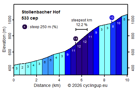
The Stollenbacher Hof is the centre of a small ski area. The climb to this former farm starts in Oberried and consists of three parts with different character. First, the road climbs gently for 4.5 kilometres (2–6%) through the beautiful valley of the Zastlerbach. Then the route leaves the valley floor by turning sharply right, which marks the beginning of the most difficult part of the ride (9–12% with the steepest stretch of 250 metres at 14%). In this part the road runs entirely through the forest, so views are scarce. This remains the case in the final section (another 2.5 kilometres), but here cycling becomes somewhat easier again, although with great variation (3–10%). Widening of the road with parking areas announces the destination of the climb, where, with a bit of luck, the terrace is open.
Rijd op 21 maart deze prachtige tocht vanuit Wageningen over de Veluwe. Keuze uit 80 en 125 km met resp. 580 en 990 hoogtemeters. Inschrijving vanaf 31 december
Tour for Life
Rijdt deze zomer de unieke en klassieke 8-daagse wielrentocht van Noord-Italië naar Zuid-Nederland voor Artsen zonder Grenzen!