
-northwest
CyclingUp: -northwest
Climbing effort: cep
Elevation meters:
Steepest kilometer: %
Steepest 250 m: %
Foot: m Top: m
Mean slope: %
Length: km
From:
Road conditions ():
Other race bikers: per hour
Motor vehicles: per hour
Scenery and road:
Restaurant or bar near top:
PHOTOS VIDEO Download gpx
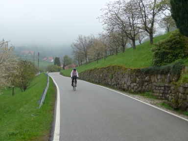

This ascent begins with the first part of the hardest climb in the Black Forest, Hornisgrinde-west. The ride begins in Achern and is easy until Saasbachwalden (maximum 6%), where the first difficult section of the Hornisgrinde-west (one kilometer of 10%) starts. This kilometer is also part of this climb but at the Straubenhof, where the route to the Hornisgrinde turns to the left, we turn to the right towards Seebach. From here to the anonymous pass, which is our destination, the climb over a narrow, quiet and winding road is a pleasure. The first kilometer is still steep (about 10%) but then cycling becomes easier (about 6%). The surroundings consist of farms, orchards and pastures. The final section, a little less than a kilometer long, runs through the forest.
Rijd op 21 maart deze prachtige tocht vanuit Wageningen over de Veluwe. Keuze uit 80 en 125 km met resp. 580 en 990 hoogtemeters. Inschrijving vanaf 31 december
Tour for Life
Rijdt deze zomer de unieke en klassieke 8-daagse wielrentocht van Noord-Italië naar Zuid-Nederland voor Artsen zonder Grenzen!