
Sand-northwest
CyclingUp: Sand-northwest
Climbing effort: 525 cep
Elevation meters: 686
Steepest kilometer: 10.4%
Steepest 250 m: 11%
Foot: 138 m Top: 824 m
Mean slope: 5.9%
Length: 11.7 km
From: Bühl
Road conditions (2016): good
Other race bikers: 0-1 per hour
Motor vehicles: >180 per hour
Scenery and road:
Restaurant or bar near top: yes
PHOTOS Download gpx

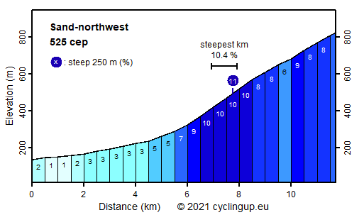
Enjoying nature is not necessarily the strongest point of this climb. The first half (six kilometers) of the ride a road with dense traffic leads through the villages of Bühl, Altschweier and Bühlertal. During the second half on the trip there is much less traffic but the road passes through a dense forest, which allows hadly any views. The ride starts in the center of Bühl. The first six kilometers through the villages begin almost horizontally and then gradually become steeper to reach 7% at the end. On entering the forest a really steep section (more than two kilometers of 10%) follows. Only after a sharp turn to the right the bike ride will become slightly easier again (8%). Soon one will get to Weidenfelsen, where one can enjoy some views down into the valley. From Weidenfelsen still one and a half kilometers (8-9%) are left until at Sand, the destination of the ascent, the Schwarzwaldhochstraße is reached.
Rijd op 21 maart deze prachtige tocht vanuit Wageningen over de Veluwe. Keuze uit 80 en 125 km met resp. 580 en 990 hoogtemeters. Inschrijving vanaf 31 december
Tour for Life
Rijdt deze zomer de unieke en klassieke 8-daagse wielrentocht van Noord-Italië naar Zuid-Nederland voor Artsen zonder Grenzen!