
Moosenmättle-west
CyclingUp: Moosenmättle-west
Climbing effort: 381 cep
Elevation meters: 514
Steepest kilometer: 10.0%
Steepest 250 m: 12%
Foot: 260 m Top: 771 m
Mean slope: 6.2%
Length: 8.2 km
From: Vor-Kirnbach
Road conditions (2018): average
Other race bikers: 0-1 per hour
Motor vehicles: 30-60 per hour
Scenery and road:
Restaurant or bar near top: yes
PHOTOS
NW N SIDE Download gpx
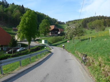
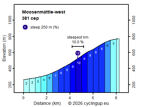
In the region around Hausach, Schiltach and Hornberg most climbs include an extremely steep section. This ascent forms an exception to this rule because even the steepest 500-meter interval (10%) causes no problem for the true climber. Because the number of elevation meters (514) is also limited, this is, alltogether, a pleasant climb. The first four kilometers of the trip run through the Untertal, where Kirnbach is located. In this village the road gradually becomes steeper. Shortly after leaving the Untertal, after a sharp left turn, the steepest section of the climb starts. This is also the beginning of the Obertal. Here one bikes through a beautiful landscape with forests, meadows and farms while the gradient measures about 8%. The last one and a half kilometers before the finish at the fork near Gasthof Mosenmättle are easy (2-6%).
Rijd op 21 maart deze prachtige tocht vanuit Wageningen over de Veluwe. Keuze uit 80 en 125 km met resp. 580 en 990 hoogtemeters. Inschrijving vanaf 31 december
Tour for Life
Rijdt deze zomer de unieke en klassieke 8-daagse wielrentocht van Noord-Italië naar Zuid-Nederland voor Artsen zonder Grenzen!