Landeckhof

CyclingUp: Landeckhof

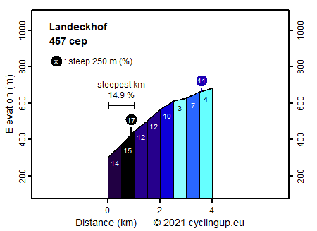
Climbing effort: 457 cep
Elevation meters: 380
Steepest kilometer: 14.9%
Steepest 250 m: 17%
Foot: 300 m Top: 680 m
Mean slope: 9.5%
Length: 4.0 km
From: Walke
Road conditions (2018): average
Other race bikers: 1-5 per hour
Motor vehicles: <10 per hour
Scenery and road:
Restaurant or bar near top: no
PHOTOS Download gpx

This climb to the Landeckhof is short (4 kilometers) but very steep. After a short approach, starting at the main street from Hausach to Walke, it goes straight into the steepest kilometer of the ride. With 14.9% this kilometer takes the second place in the list of the steepest kilometers in the Black Forest on this website. The following one and a half kilometers are also viciously steep (10-12%). Only after that the ride becomes a pleasure trip (3-7%). After the highest point a short descend ends the tour at the Landeckhof, a farm without a restaurant or café. In addition to being very steep, the road is really quiet but also, depending on the conditions, difficult to descend. When I biked here, the asphalt was partially wet and covered with the yellow pollen of the spruce and therefore slippery. The route is easy to find. Just follow the signs "Landeckhof".


Rijd op 22 maart deze prachtige tocht over de Veluwe, 75 of 125 kilometer vanuit Wageningen. Met veel hoogtemeters: resp. 550 en 970. Inschrijving
1K Ride
Rijd op 15 juni deze tocht met meer dan 1000 hoogtemeters; 80, 120 of 145 kilometer vanuit Oosterbeek. Inschrijving
Tour for Life
Rijdt deze zomer de unieke en klassieke 8-daagse wielrentocht van Noord-Italië naar Zuid-Nederland voor Artsen zonder Grenzen!

