
Kostgefäll
CyclingUp: Kostgefäll
Climbing effort: 539 cep
Elevation meters: 560
Steepest kilometer: 12.4%
Steepest 250 m: 14%
Foot: 360 m Top: 920 m
Mean slope: 8.6%
Length: 6.5 km
From: Simonswald
Road conditions (2025): good
Other race bikers: 1-5 per hour
Motor vehicles: <10 per hour
Scenery and road:
Restaurant or bar near top: no
PHOTOS Download gpx
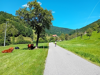
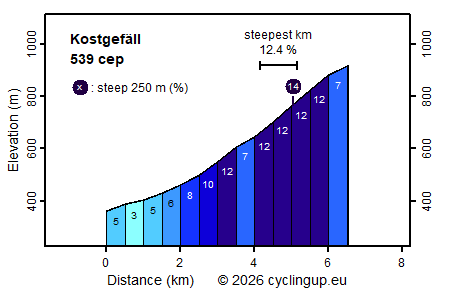
Before starting this climb to Kostgefäll from the Simonswäldertal, we knew that we would be cycling 6.5 kilometres and gaining 560 metres of elevation. That corresponds to an average gradient of 8.6%, which is quite demanding. We set off, and the first two kilometres turned out to be easy (3–6%). That was pleasant, but also a bad sign, because in order to still reach an average of 8.6%, the remaining 4.5 kilometres would have to be very steep. And that was the case, of course. While we were still biking in the valley, the gradient of the road increased to 12%. After crossing the stream it became slightly easier (7%), but soon the hardest part of the entire ride followed, namely two kilometres with a constant gradient of 12%. The final few hundred metres were easier again (7%). Anyone who wants to see something of the surroundings should do so before crossing the stream. After that, only occasional views open up from the forest.
Rijd op 21 maart deze prachtige tocht vanuit Wageningen over de Veluwe. Keuze uit 80 en 125 km met resp. 580 en 990 hoogtemeters. Inschrijving vanaf 31 december
Tour for Life
Rijdt deze zomer de unieke en klassieke 8-daagse wielrentocht van Noord-Italië naar Zuid-Nederland voor Artsen zonder Grenzen!