


Herrenschwander Kopf-west

CyclingUp: Herrenschwander Kopf-west

Climbing effort: 536 cep
Elevation meters: 644
Steepest kilometer: 11.2%
Steepest 250 m: 13%
Foot: 520 m Top: 1089 m
Mean slope: 5.4%
Length: 10.6 km
From: Wembach
Road conditions (2017): average
Other race bikers: 0-1 per hour
Motor vehicles: <10 per hour
Scenery and road:
 (4/5)
(4/5) Restaurant or bar near top: no
PHOTOS Download gpx

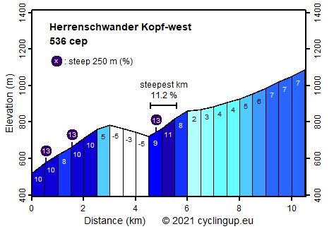
This wonderful climb includes both very steep as well as gently rising sections. The road leads through a beautiful, steep landscape dominated by meadows and small villages against the backdrop of the mighty Belchen. The road is very quiet. We met a single car on the way to the top and back. The ride begins at the turnoff from the B317 in the direction of Künaberg. The first two and a half kilometers are steep (typically 10%). In the third hamlet (Holz) a culminating point is reached. This is followed by a descent (75 elevation meters). After passing the Künabach at the saw mill (Klopfsäge in German), the street goes up again. Here lies the steepest kilometer (11.2%) of the ascent. After a kilometer and a half the road suddenly becomes less steep (2%), so one can enjoy the view. A sharp turn to the left follows. One and a half kilometers further, at a parking lot, we take the asphalted, rising road to the left. The remaining one and a half kilometers run almost completely through the forest, are moderately steep (7%) and a little boring.
Rijd op 29 augustus deze prachtige klimtocht vanuit Wageningen over de Veluwe, door Montferland, Reichswald en Rijk van Nijmegen. Keuze uit 105 en 155 km met resp. 800 en 1180 hoogtemeters. Inschrijving vanaf nu
Tour for Life
Rijdt deze zomer de unieke en klassieke 8-daagse wielrentocht van Noord-Italië naar Zuid-Nederland voor Artsen zonder Grenzen!