Gisiboden Alm

CyclingUp: Gisiboden Alm

Climbing effort: 568 cep
Elevation meters: 592
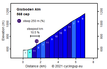
Steepest kilometer: 10.5%
Steepest 250 m: 13%
Foot: 578 m Top: 1170 m
Mean slope: 8.4%
Length: 7.0 km
From: Geschwend
Road conditions (2017): average
Other race bikers: 0-1 per hour
Motor vehicles: <10 per hour
Scenery and road:
Restaurant or bar near top: yes
PHOTOS Download gpx

This is a wonderful climb for road bikers. A narrow street with almost no traffic but with a relatively good pavement, leads mostly through the forest to the Gisiboden Alm. There you have a splendid view, among other things on the Belchen. The ride begins at the turnoff of the B317 to Todtmoos. Just follow the signs to Gisiboden Alm through the village of Geschwend. After a kilometer, still in the village, the road becomes steep. On the remaining six kilometers 566 elevation meters must still be gained. This gives an average slope of 9.4%. The steepest of these six kilometers is the first (10.5%). A kilometer and a half before the end you leave the forest and bike, slightly less steep than before (7-9%), across the alpine meadows to the inn.


Rijd op 22 maart deze prachtige tocht over de Veluwe, 75 of 125 kilometer vanuit Wageningen. Met veel hoogtemeters: resp. 550 en 970. Inschrijving
1K Ride
Rijd op 15 juni deze tocht met meer dan 1000 hoogtemeters; 80, 120 of 145 kilometer vanuit Oosterbeek. Inschrijving
Tour for Life
Rijdt deze zomer de unieke en klassieke 8-daagse wielrentocht van Noord-Italië naar Zuid-Nederland voor Artsen zonder Grenzen!

