Bäracker

CyclingUp: Bäracker

Climbing effort: 498 cep
Elevation meters: 490
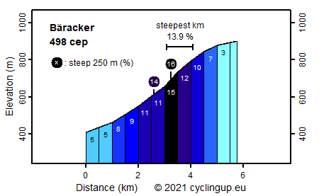
Steepest kilometer: 13.9%
Steepest 250 m: 16%
Foot: 410 m Top: 900 m
Mean slope: 8.5%
Length: 5.8 km
From: Niederwasser
Road conditions (2018): average
Other race bikers: 0-1 per hour
Motor vehicles: 10-30 per hour
Scenery and road:
Restaurant or bar near top: yes
PHOTOS Download gpx

Like almost all other climbs in the Wolfach-Schiltach-Triberg region, the climb to Bäracker contains a terribly steep section. Maybe that's why we hardly met other road cyclists in this region. The ascent begins in the valley of the Gutach River, just south of the village of Niederwasser. Always follow the signs "Hotel Schöne Aussicht", which is located in the immediate vicinity of the destination. The slope is yet pleasant in the first kilometer (5%) but when riding past two farms cycling becomes harder (9%). This is followed by a kilometer, through the forest, with a slope of 11%. However, this is only a prelude. After a right-angled bend to the right, climbing gets really serious with a kilometer of 13.9% and a 250 meter strip of 16%. Only after a farm the slope returns to a reasonably normal value (10%). The last kilometer to Bäracker is pretty easy.


Rijd op 21 maart deze prachtige tocht vanuit Wageningen over de Veluwe. Keuze uit 80 en 125 km met resp. 580 en 990 hoogtemeters. Inschrijving vanaf 31 december
Tour for Life
Rijdt deze zomer de unieke en klassieke 8-daagse wielrentocht van Noord-Italië naar Zuid-Nederland voor Artsen zonder Grenzen!

