
CyclingUp:
Climbing effort: cep
Elevation meters:
Steepest kilometer: %
Steepest 250 m: %
Foot: m Top: m
Mean slope: %
Length: km
From:
Road conditions ():
Other race bikers: per hour
Motor vehicles: per hour
Scenery and road:
Restaurant or bar near top:
PHOTOS VIDEO Download gpx
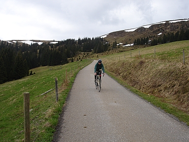
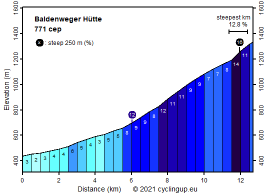
This is one of the toughest climbs in the Black Forest, partly because of the very steep final part. We begin the ascent, coming on the L126 from Kirchzarten, at the first exit to Oberried. We take this exit and turn soon to the left towards Zastler. The first 5.5 kilometers rise gently (2-6%) through a beautiful valley. Initially the road is wide but it gets narrow after the junction to the Stollenbacherhof. Two kilometers further the slope steepens when we enter the forest. Both steepness and forest will then remain the attributes of the next six kilometers to Rinken, a pass. In the middle of this section there is an extra steep part (11-12%) of one and a half kilometers. During the last kilometer before Rinken the road is unpaved. In Rinken we turn right twice to start with the final and hardest section of the trip. The first 500 meters are among the steepest in the Black Forest (average 14%). At the same time the landscape is getting more interesting. We leave the forest and look, first in front of us, on the Feldberg, where in the beginning of May, when I was here, quite a few patches of snow were left. Behind us a wide view opens. The aim is not the Baldenweger Hütte itself but the Naturfreundehaus Feldberg, resulting in twelve additional elevation meters.
Rijd op 21 maart deze prachtige tocht vanuit Wageningen over de Veluwe. Keuze uit 80 en 125 km met resp. 580 en 990 hoogtemeters. Inschrijving vanaf 31 december
Tour for Life
Rijdt deze zomer de unieke en klassieke 8-daagse wielrentocht van Noord-Italië naar Zuid-Nederland voor Artsen zonder Grenzen!