Ebnit

CyclingUp: Ebnit

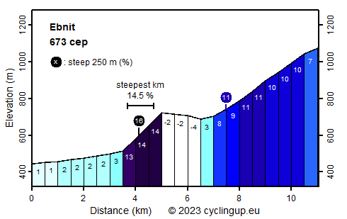
Climbing effort: 673 cep
Elevation meters: 681
Steepest kilometer: 14.5%
Steepest 250 m: 16%
Foot: 445 m Top: 1074 m
Mean slope: 5.7%
Length: 11.1 km
From: Dornbirn
Road conditions (2022): average
Other race bikers: 0-1 per hour
Motor vehicles: 30-60 per hour
Scenery and road:
Restaurant or bar near top: yes
PHOTOS Download gpx

There are two good reasons to cycle from Dornbirn to Ebnit. First, the climb includes a magnificent section for the true mountain specialist. It begins after the almost horizontal first 3.5 kilometers, is about 1.5 km long and includes a steepest kilometer of 14.5%. When I cycled here in 2022 the bridge that crosses the valley halfway through this steep passage was closed. So I had to make a detour around a reservoir. After the steep passage 45 elevation meters are lost in a descent. The subsequent part is the second attraction of this climb and will especially appeal to canyon friends. The road lies at the bottom of a gorge and passes through a series of short tunnels. Because the tunnels are not illuminated, it is recommended to take light with you. From the beginning of the gorge to the end of the ride at the church in Ebnit (another 4 kilometers) the road is steep again (often 10-11%). An inn for drinks and snacks lies along the road about a kilometer behind the church.


Rijd op 30 augustus deze prachtige klimtocht vanuit Wageningen over de Veluwe, door Montferland, Reichswald en Rijk van Nijmegen. Keuze uit 105 en 155 km met resp. 750 en 1130 hoogtemeters. Inschrijven vanaf 22 juni
Tour for Life
Rijdt deze zomer de unieke en klassieke 8-daagse wielrentocht van Noord-Italië naar Zuid-Nederland voor Artsen zonder Grenzen!

