
Brandnertal
CyclingUp: Brandnertal
Climbing effort: 837 cep
Elevation meters: 1036
Steepest kilometer: 10.9%
Steepest 250 m: 14%
Foot: 550 m Top: 1566 m
Mean slope: 6.0%
Length: 17.0 km
From: Bludenz
Road conditions (2021): excellent
Other race bikers: 0-1 per hour
Motor vehicles: 30-60 per hour
Scenery and road:
Restaurant or bar near top: no
PHOTOS Download gpx

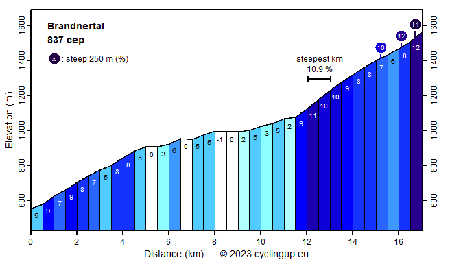
The ascent from Bludenz through the Brandnertal leads over a cul-de-sac that ends at the parking lot of the Lünerseebahn and has a splendid last part. This part begins after cycling more than 11 kilometers at the end of the build-up area of Brand. Here the road narrows and the mountains become particularly beautiful. Lush green dominates the valley while higher up and in front of the cyclist the view of the Schesaplana, with 2965 meters the highest peak of the Rätikon, unfolds. Two kilometers after Brand, the road turns left so other peaks become visible. This last part of the climb is steep. Over a distance of 5.5 kilometers 491 meters of altitude are gained (on average 8.9%). The steepest kilometer (10.9%) lies just after Brand while the steepest 250 meter section (14%) has to be cycled on the parking lot at the destination. The first two parts of the ride are less exciting. The first part, starting at the Brandnertal exit of the A14, is moderately steep (5 kilometers with a slope of 5-9%) whereas the middle part (6.5 kilometers) is easy (-1 to 6%).
Rijd op 21 maart deze prachtige tocht vanuit Wageningen over de Veluwe. Keuze uit 80 en 125 km met resp. 580 en 990 hoogtemeters. Inschrijving vanaf 31 december
Tour for Life
Rijdt deze zomer de unieke en klassieke 8-daagse wielrentocht van Noord-Italië naar Zuid-Nederland voor Artsen zonder Grenzen!