
Bielerhöhe-northwest
CyclingUp: Bielerhöhe-northwest
Climbing effort: 833 cep
Elevation meters: 991
Steepest kilometer: 10.1%
Steepest 250 m: 13%
Foot: 1051 m Top: 2037 m
Mean slope: 6.9%
Length: 14.4 km
From: Partenen
Road conditions (2021): excellent
Other race bikers: 5-10 per hour
Motor vehicles: 10-30 per hour
Scenery and road:
Restaurant or bar near top: yes
PHOTOS Download gpx

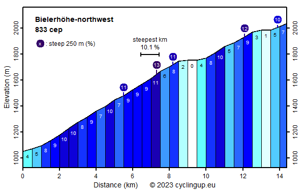
The ascent from the Montafon to the Bielerhöhe runs along the Silvretta-Hochalpenstraße and it's pretty hard sure if this, as for me, is the first high mountain climb since the winter, if the atmosphere is hot and humid and if one knee is not in optimal shape. Fortunately, beyond the Vermunt reservoir, for the last 5 kilometers, rugged mountains with still a lot of snow (when I drove up here) gave a superb reward. On this website the ride starts at the church in Partenen, where the road through the Montafon becomes noticeably steeper. One and a half kilometer further on, at the toll gate, the hardest part of the trip begins: six kilometers with an average gradient of 8.9%, including a steepest kilometer of 10.1%. This is also where most of the 30 hairpin turns between Partenen and the pass are located. Shortly before the Vermunt reservoir, the character of the road changes. From here to the pass, the slope varies greatly (0 to 10 percent for the 500 meter segments). At the finish some terraces are waiting where you can recover from the efforts.
Rijd op 22 maart deze prachtige tocht over de Veluwe, 75 of 125 kilometer vanuit Wageningen. Met veel hoogtemeters: resp. 550 en 970. Inschrijving
1K Ride
Rijd op 15 juni deze tocht met meer dan 1000 hoogtemeters; 80, 120 of 145 kilometer vanuit Oosterbeek. Inschrijving
Tour for Life
Rijdt deze zomer de unieke en klassieke 8-daagse wielrentocht van Noord-Italië naar Zuid-Nederland voor Artsen zonder Grenzen!