
Umbrailpass-Stelvio
CyclingUp: Umbrailpass-Stelvio
Climbing effort: 1238 cep
Elevation meters: 1400
Steepest kilometer: 10.2%
Steepest 250 m: 12%
Foot: 1370 m Top: 2757 m
Mean slope: 8.3%
Length: 16.6 km
From: Santa_Maria
Road conditions (2015): good
Other race bikers: 1-5 per hour
Motor vehicles: 30-60 per hour
Scenery and road:
Restaurant or bar near top: yes
PHOTOS VIDEO
E W SIDE Download gpx
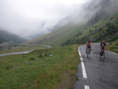

This climb combines those to the highest mountain passes of Switzerland, the Umbrailpass (2501 m), and of Italy, the Passo dello Stelvio (Stilfserjoch in German; 2757 m). This Swiss version of the Stelvio is certainly not as impressive as the ascent from the east and less popular than the western ascent from Bormio but it is by far the most quiet of the three options. The road is often narrow and in 2015 the pavement was in very good condition. Formerly a part of the road was unpaved but this romance is a thing of the past. The trip begins in Santa Maria, a village situated at the altitude of 1370 meters in the Val Müstair. From there, the road runs through the Val Muraunza to the Umbrailpass, then loses 11 elevation meters before it joins the road from Bormio to the Stelvio and ends with the last 270 meters of altitude of the western ascent. The scenery is beautiful and numerous hairpin bends (about 40, in total) provide new aims all the time. However, the profile is quite monotonous. Out of the 33 intervals of 500 meters, 27 have a gradient of 8-10%. The climb can be extended with the ride from Glurns (Glorienza) in Italy to Santa Maria. This adds another 14.4 kilometers, 474 meters of altitude and 250 climb effort points.
Rijd op 29 augustus deze prachtige klimtocht vanuit Wageningen over de Veluwe, door Montferland, Reichswald en Rijk van Nijmegen. Keuze uit 105 en 155 km met resp. 800 en 1180 hoogtemeters. Inschrijving vanaf nu
Tour for Life
Rijdt deze zomer de unieke en klassieke 8-daagse wielrentocht van Noord-Italië naar Zuid-Nederland voor Artsen zonder Grenzen!