HOME cyclingup.eu

regions

method
contact
links
French Alps
Switzerland
Austria
Italian Alps
French Pyrenees
Spain
Gran Canaria
Vosges
Black Forest
Brocken, Germany
Ardennes
Netherlands


-south

CyclingUp: -south

Climbing effort: cep
Elevation meters:
Steepest kilometer: %
Steepest 250 m: %
Foot: m Top: m
Mean slope: %
Length: km
From:
Road conditions ():
Other race bikers: per hour
Motor vehicles: per hour
Scenery and road:
 (/5)
(/5) Restaurant or bar near top:
PHOTOS VIDEO Download gpx
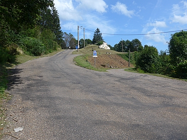
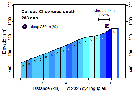
Among the three climbs to the Col des Chevrères the climb of this page, from the south and starting in Plancher-Bas, is the easiest one. The first seven kilometers lead from the T-junction of the D16 and the D97 in Plancher-Bas, via the Col de la Chevestraye to Belfahy. In this part the road is nowhere more than moderately steep; large parts have a gradient 5-6%. The last one and a half kilometers are more exciting. First there is a short ramp (with a 250 meter section of 14%), which is followed by an almost horizontal section. The ride finishes with a short, steep section.
Germania klimtocht
Rijd op 29 augustus deze prachtige klimtocht vanuit Wageningen over de Veluwe, door Montferland, Reichswald en Rijk van Nijmegen. Keuze uit 105 en 155 km met resp. 800 en 1180 hoogtemeters. Inschrijving vanaf nu
Tour for Life
Rijdt deze zomer de unieke en klassieke 8-daagse wielrentocht van Noord-Italië naar Zuid-Nederland voor Artsen zonder Grenzen!
Rijd op 29 augustus deze prachtige klimtocht vanuit Wageningen over de Veluwe, door Montferland, Reichswald en Rijk van Nijmegen. Keuze uit 105 en 155 km met resp. 800 en 1180 hoogtemeters. Inschrijving vanaf nu
Tour for Life
Rijdt deze zomer de unieke en klassieke 8-daagse wielrentocht van Noord-Italië naar Zuid-Nederland voor Artsen zonder Grenzen!