Cirque de Troumouse

CyclingUp: Cirque de Troumouse

Climbing effort: 1008 cep
Elevation meters: 1421
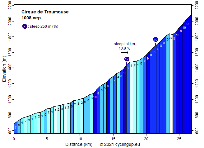
Steepest kilometer: 10.8%
Steepest 250 m: 12%
Foot: 685 m Top: 2090 m
Mean slope: 5.2%
Length: 26.9 km
From: Luz-St-Sauveur
Road conditions (2014): average
Other race bikers: 5-10 per hour
Motor vehicles: 60-180 per hour
Scenery and road:
Restaurant or bar near top: no
PHOTOS VIDEO Download gpx

This is a challenging ascent with steep sections separated by easy parts that allow recuperation. After the rather uninteresting preamble from Luz-St-Sauveur on the D921, the tour suddenly gets exiting when the D922 is entered just above Gèdre. The first 5.5 kilometers after the junction are variable in steepness (4-11%), with the steepest part just before the road to the Lac de Gloriettes splits off to the right. Beautiful farmlands and nice views of the mountains ahead help to enjoy this stretch. The 2 kilometers after the mentioned junction are easy (1-5%) but on passing the toll house pleasure begins again. For the next 3.5 kilometers the road winds itself up with a slope of 8%. Views on the surroundings mountains are great. Then, a short descend (16 elevation meters) leads to the Auberge du Maillet, where on sunny days you may pass a queue of tourists waiting for the bus to continue their trip to the cirque. We do not need to bother about waiting but can finish the ascent with the, from a climbing perspective, nicest part. It is a climb on an almost empty, narrow and steep (9-10%) road with 12 hairpin turns that bridge 250 elevation meters. At the end there is the reward of the cirque.


Rijd op 21 maart deze prachtige tocht vanuit Wageningen over de Veluwe. Keuze uit 80 en 125 km met resp. 580 en 990 hoogtemeters. Inschrijving vanaf 31 december
Tour for Life
Rijdt deze zomer de unieke en klassieke 8-daagse wielrentocht van Noord-Italië naar Zuid-Nederland voor Artsen zonder Grenzen!

