Sulden

CyclingUp: Sulden

Climbing effort: 780 cep
Elevation meters: 1025
Steepest kilometer: 11.4%
Steepest 250 m: 12%
Foot: 911 m Top: 1916 m
Mean slope: 5.7%
Length: 17.7 km
From: Prad
Road conditions (2015): good
Other race bikers: 5-10 per hour
Motor vehicles: 60-180 per hour
Scenery and road:
Restaurant or bar near top: yes
PHOTOS Download gpx

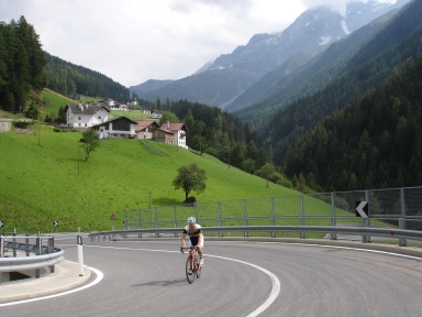
One could call the climb to Sulden (Solda in Italian) the little brother of the climb to the Passo dello Stelvio. Meanwhile though, this little brother counts more than 1000 elevation meters. The first 6.5 km to Gomagoi the route is identical to that to the Stelvio. This part is a warming up (large parts of 7%). In Gomagoi you turn to the left and a kilometer further, after crossing the brook of the Suldenbach, climbing gets serious. For the following three kilometers the slope is mostly 11%. At the end of this section when leaving the forest, the mighty Ortler (3905 meters) becomes visible. After two easy kilometers (3-6%) a short steep passage (10%) with four hairpin turns follows. Soon after that, Sulden is reached. The elongated resort is located in a relatively flat part of the valley. One feels here as in Austria. The ride ends at the car park of the lift at the back of the village. At that place there is a wonderful view, among others on the steep north face of the Königsspitze (Gran Zebrú, 3859 meters).


Rijd op 21 maart deze prachtige tocht vanuit Wageningen over de Veluwe. Keuze uit 80 en 125 km met resp. 580 en 990 hoogtemeters. Inschrijving vanaf 31 december
Tour for Life
Rijdt deze zomer de unieke en klassieke 8-daagse wielrentocht van Noord-Italië naar Zuid-Nederland voor Artsen zonder Grenzen!

