
Schnalstal
CyclingUp: Schnalstal
Climbing effort: 1151 cep
Elevation meters: 1487
Steepest kilometer: 11.7%
Steepest 250 m: 13%
Foot: 548 m Top: 2025 m
Mean slope: 6.2%
Length: 23.7 km
From: Naturns
Road conditions (2015): average
Other race bikers: 1-5 per hour
Motor vehicles: 60-180 per hour
Scenery and road:
Restaurant or bar near top: yes
PHOTOS Download gpx
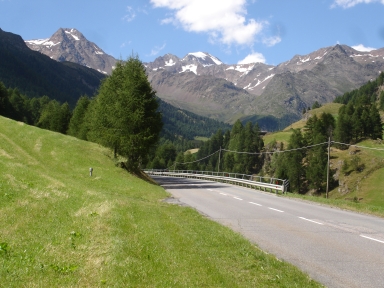

The climb to Kurzras (Maso Corto in Italian) through the Schnalstal (Val Senales) presents quite a task because of the almost 1500 elevation meters. The profile of the ascent is mostly determined by the profile of the valley and because the later is not a straight line upwards, the slope of the road varies significantly. There are some sections where you can really relax. The 2.5 kilometers along the Vernagt reservoir are more or less horizontal and the easiest. However, there are four parts where the slope of the 500-meter-intervals measures at least 10%. The ride begins with two steep kilometers, of which the first one lies in a tunnel. The steepest part (11%) of this secion is found immediately after the tunnel. The second and the steepest among the at-least-ten-percent section is encountered after eight kilometers ride, before and after the turnoff into the Pfossental. This passage includes the steepest kilometer (11.7%) of the trip. Also in the hairpin turns leading up to the reservoir and shortly before the finish the gradient reaches some 10%. High up in the Schanlstal, near the Hauslabjoch Ötzi was found.
Rijd op 21 maart deze prachtige tocht vanuit Wageningen over de Veluwe. Keuze uit 80 en 125 km met resp. 580 en 990 hoogtemeters. Inschrijving vanaf 31 december
Tour for Life
Rijdt deze zomer de unieke en klassieke 8-daagse wielrentocht van Noord-Italië naar Zuid-Nederland voor Artsen zonder Grenzen!