Passo Fedaia-west

CyclingUp: Passo Fedaia-west

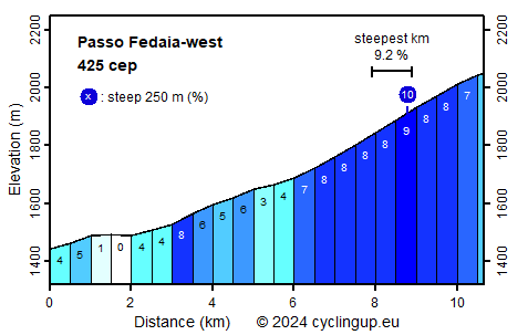
Climbing effort: 425 cep
Elevation meters: 617
Steepest kilometer: 9.2%
Steepest 250 m: 10%
Foot: 1442 m Top: 2054 m
Mean slope: 5.7%
Length: 10.7 km
From: Canazei
Road conditions (2016): good
Other race bikers: 10-25 per hour
Motor vehicles: 60-180 per hour
Scenery and road:
Restaurant or bar near top: yes
PHOTOS
E SIDE Download gpx

The Passo Fedaia is located at the foot of Marmolada, with 3343 meters the highest peak in the Dolomites . During the First World War the front between the Italian and the Austrian army ran across the glacier on the north side of the mountain. For the supply and for shelter tunnels were cut out in the ice. Many soldiers fell victim to snow avalanches. One could divide the climb from Canazei to Fedaia in three parts. The first three kilometers until Penia are very easy (0-5%). At Penia the, for some time, last buildings are left behind and with some long turns one enters into the middle section where the slope increases to between 3 and 8%. More than three kilometers further on, the road leaves the valley bottom and the final part with a slope of mostly 8% begins. First, the road winds itself up with four hairpin bends. What follows is a three-kilometer-long traverse, in which the view becomes more and more beautiful. The ascent ends at the dam of the reservoir (Lago di Fedaia). It is still worth to cycle along the lake because of the view of the Marmolada, its glaciers and the lake itself.


Rijd op 30 augustus deze prachtige klimtocht vanuit Wageningen over de Veluwe, door Montferland, Reichswald en Rijk van Nijmegen. Keuze uit 105 en 155 km met resp. 750 en 1130 hoogtemeters. Inschrijven vanaf 22 juni
Tour for Life
Rijdt deze zomer de unieke en klassieke 8-daagse wielrentocht van Noord-Italië naar Zuid-Nederland voor Artsen zonder Grenzen!

