Timmelsjoch-west

CyclingUp: Timmelsjoch-west

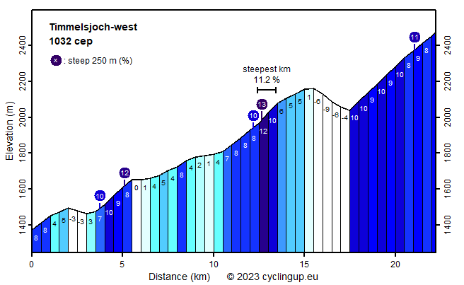
Climbing effort: 1032 cep
Elevation meters: 1278
Steepest kilometer: 11.2%
Steepest 250 m: 13%
Foot: 1370 m Top: 2474 m
Mean slope: 5.0%
Length: 22.2 km
From: Sölden
Road conditions (2015): good
Other race bikers: 10-25 per hour
Motor vehicles: 60-180 per hour
Scenery and road:
Restaurant or bar near top: yes
PHOTOS VIDEO
SE SIDE Download gpx

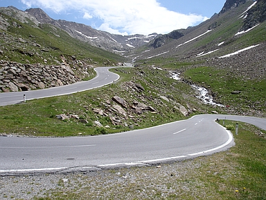
The second half of this ascent, beginning in Obergurgl, is great. There are steep sections and magnificent views of snow- and ice-covered mountains, for example the Ramolkogel (3549 m) and the Schalfkogel (3537 meters), both of which lie south of Obergurgl. The last kilometers to the pass are very scenic. The first eleven kilometer till Obergurgl are less interesting. There are some steep sections, in particular the first kilometer (8%) and the first two kilometers after Zwieselstein (7-10%). Other parts are easier, sometimes almost horizontal or even going slightly downhill. Here, the traffic can be quite strong, with motor bikes well represented. The first 2.5 kilometers after Obergurgl, when the road crosses a beautiful, open forest, are quite steep with a steepest kilometer of over 11%. After the toll gate there is a significant descent, where 130 elevation meters are lost. The final five kilometers are hard. Often, the slope measures 10% and the thinning air is also an important opponent. The Timmelsjoch (Passo del Rombo in Italian) is located on the border between Austria and Italy. Its altitude is not, as the signs at the pass indicate, 2509 meters but 2474 meters.


Rijd op 30 augustus deze prachtige klimtocht vanuit Wageningen over de Veluwe, door Montferland, Reichswald en Rijk van Nijmegen. Keuze uit 105 en 155 km met resp. 750 en 1130 hoogtemeters. Inschrijven vanaf 22 juni
Tour for Life
Rijdt deze zomer de unieke en klassieke 8-daagse wielrentocht van Noord-Italië naar Zuid-Nederland voor Artsen zonder Grenzen!

