
Sattele-northwest
CyclingUp: Sattele-northwest
Climbing effort: 1083 cep
Elevation meters: 1007
Steepest kilometer: 12.5%
Steepest 250 m: 14%
Foot: 683 m Top: 1690 m
Mean slope: 10.4%
Length: 9.7 km
From: Haiming
Road conditions (2019): good
Other race bikers: 1-5 per hour
Motor vehicles: 60-180 per hour
Scenery and road:
Restaurant or bar near top: no
PHOTOS Download gpx

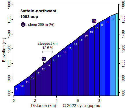
The ascent to the so-called Sattele (Austrian for small mountain pass), also called Silzer Sattel, from the Inn Valley is certainly not a child's play. In total, the road gains 1007 elevation meters over a horizontal distance of only 9.7 kilometers. So, on average, the gradient is 10.4%. Because the last one and a half kilometers are a bit easier (6-8%), the first eight kilometers are steeper than those 10.4%, namely 11.0%, on average. Fortunately, within these eight kilometers there are hardly any outliers to even higher percentages. This wonderful steepness is not the only advantage of this ascent. The cyclist may also enjoy the beautiful views of the Inn Valley and the mountains beyond. A little disappointing were the traffic, which was relatively dense for a white street on the map, and the Sattele itself, which is an insignificant place.
Rijd op 21 maart deze prachtige tocht vanuit Wageningen over de Veluwe. Keuze uit 80 en 125 km met resp. 580 en 990 hoogtemeters. Inschrijving vanaf 31 december
Tour for Life
Rijdt deze zomer de unieke en klassieke 8-daagse wielrentocht van Noord-Italië naar Zuid-Nederland voor Artsen zonder Grenzen!