HOME cyclingup.eu

regions

method
contact
links
French Alps
Switzerland
Austria
Italian Alps
French Pyrenees
Spain
Gran Canaria
Vosges
Black Forest
Brocken, Germany
Ardennes
Netherlands
-south
CyclingUp: -south
Climbing effort: cep
Elevation meters:
Steepest kilometer: %
Steepest 250 m: %
Foot: m Top: m
Mean slope: %
Length: km
From:
Road conditions ():
Other race bikers: per hour
Motor vehicles: per hour
Scenery and road:
Restaurant or bar near top:
PHOTOS VIDEO Download gpx
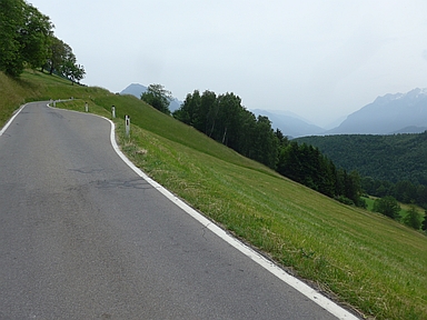

The ascent from the Ill valley to Dünserberg is a pleasant ride over a mostly narrow street. The trip itself takes place at some distance from the high mountains, but offers many views of high peaks, especially those of the Rätikon further south. When I cycled here, this view was blurred considerably, according to the Austrian weather services by dust originating from the Sahara (see my photos). The climb has several variants. I decided to start in Satteins and cycle up via Röns, Düns and Bassigg. The steepest sections lie between Röns and Düns (one and a half kilometers with 7-9%) and before and in Bassigg (two kilometers with 8-12%).
Germania klimtocht
Rijd op 29 augustus deze prachtige klimtocht vanuit Wageningen over de Veluwe, door Montferland, Reichswald en Rijk van Nijmegen. Keuze uit 105 en 155 km met resp. 800 en 1180 hoogtemeters. Inschrijving vanaf nu
Tour for Life
Rijdt deze zomer de unieke en klassieke 8-daagse wielrentocht van Noord-Italië naar Zuid-Nederland voor Artsen zonder Grenzen!