
St. Anton-northeast
CyclingUp: St. Anton-northeast
Region: Switzerland
Climbing effort: 535 cep
Elevation meters: 722
Steepest kilometer: 11.1%
Steepest 250 m: 12%
Foot: 465 m Top: 1108 m
Mean slope: 5.1%
Length: 12.7 km
From: Altstätten
Road conditions (2021): excellent
Other race bikers: 1-5 per hour
Motor vehicles: 30-60 per hour
Scenery and road:
![]() (2/5)
(2/5)
Restaurant or bar near top: yes
PHOTOS
Download gpx

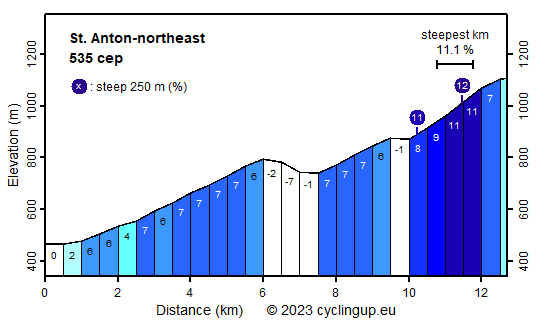
This 13-kilometer ascent from Altstätten to St. Anton runs through a part of Switzerland, where the map of the cantons is chaotic. During this trip one cycles through three cantons, first three kilometers through Sankt Gallen, then about seven kilometers through Appenzell Ausserrhoden and finally, starting from Oberegg, another three kilometers through an enclave of Appenzell Innerrhoden. Because of its location on a ridge St. Anton offers a wonderful panorama, including the Alpstein (Säntis), the Rätikon, the Rhine Valley and the Bregenzerwald. During the first ten kilometers of the ride, from Alstätten to Oberegg, the road is mostly moderately steep (maximum 7%). Moreover, after 6 kilometers, near Reute, the climb is interrupted by a descent (70 elevation meters). After Oberegg there are still three kilometers to the finish. These are the toughest of the whole trip with a steepest kilometer of 11.1%.
Rijdt deze zomer de unieke en klassieke 8-daagse wielrentocht van Noord-Italië naar Zuid-Nederland voor Artsen zonder Grenzen!