
Cerro de Miranda-east
CyclingUp: Cerro de Miranda-east
Region: Spain
Climbing effort: 382 cep
Elevation meters: 600
Steepest kilometer: 7.9%
Steepest 250 m: 12%
Foot: 464 m Top: 1005 m
Mean slope: 4.4%
Length: 12.3 km
From: Rágol
Road conditions (2019): excellent
Other race bikers: 0-1 per hour
Motor vehicles: 60-180 per hour
Scenery and road:
![]() (1/5)
(1/5)
Restaurant or bar near top: no
PHOTOS
Download gpx
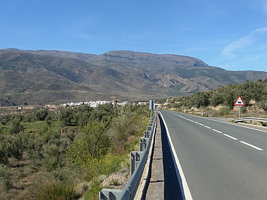
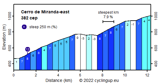
At the junction with the side-road towards Ohanes, the A348 begins with a considerable climb in easterly direction. In itself this climb is not spectacular but as part of a round trip this ascent, named Cero de Miranda, should be noted. The pass height, which is reached about three and a half kilometers after passing the village of Almocíta, is not even marked by a sign or something similar. In addition, the magnitude of the strongly varying slope (-3 to 8% for the 500-meter intervals) does not make this ride outstanding. Although the road runs through the Parque Natural de Sierra Nevada, there is not much natural beauty around the road. This is emphasized by the road, which is not picturesque at all and wide so motorvehicles drive fast.
For tours in the splendid and varied nature of Asturias.
Grazalema Cycling Adventures offers guided bike tours and rents road, mountain and electric bikes in splendid Andalusia.
Camping Alpujarras in Laroles, along the road to the Puerto de la Ragua, offers superb views, green grass, good meals and great hospitality.
Rijdt deze zomer de unieke en klassieke 8-daagse wielrentocht van Noord-Italië naar Zuid-Nederland voor Artsen zonder Grenzen!